| Mountaineering
Across the Himalayas - Part 5
|
|||||
Towards our final destination:
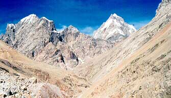
"Karakoram"-the word itself sent tingling sensations of excitement down my spine. I had walked in the footsteps of history - bones and skeletal remains along the trail were grim reminders of former travelers who had not been as lucky. Our guide Norbu was full of stories of Yarkhandis who in the past had attempted the perilous journey to Mecca - men, women and children with their laden horses, striking out into the unknown, driven only by the will to continue against all odds. How different from our venture - and yet how similar.
Our route proceeded via Khardung Village, Khalsar and Panamic to Sasoma (meaning New Land) along the Nubra River, 158 kms from Leh. Norbu, a guide from the Ladakh Scouts, met us here. A tough Ladakhi, he had expressed doubts over whether an old lady and three fragile-looking women would make it. However the driver of the army truck, who came as support team from Leh upto Sasoma, assured him that we were quite capable. We had taken three days to walk 119 kms from Khardung La to Sasoma.
|
Mountaineering
Adventure activities
Travelogues | ||||
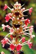
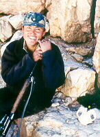
Now had another tough lady - Kara, the dog who had accompanied us since North Pulu beyond Khardungla. All attempts to dissuade her had failed. She was determined to be part of our team. Our first destination was Turtaylak which we reached after climbing 36 bends and crossing the Tulung Putila (3,595 m). This trail was built by Ali Hussain in 1646. One admires his architectural skill and knowledge as one gains height towards the pass. The trek In the Himalayan Journal (Vol. 37 page 118) Amir Ali writes, "It is not just in recent years that the pass has been frequently used. It has always been a highway for people and traders from the North coming down through the Karakorams to gentler and more fertile climes. The Yarkandis used this route for trade and for going on Haj to Mecca. We had been told by just about everyone that the route would be strewed with bones of animals - perhaps men - who had perished in the cold. But it was quite astonishing to see the quantities of these bones.  There were piles At Saser Brangza the soldiers and occupants of the army camps were quite flabbergasted to see women suddenly descending down on them as it were! Their words of praise and encouragement touched us deeply. Our next stage was to cross the river Shyok. Known as the river of death, its murky black waters can bring a chill to the heart as much as its swift icy waters can chill your body. The horses plunged in swimming expertly but we took the aerial route on the Garari. Delicate flowers were blooming despite the hot dry stony surroundings. Karakoram is a geologist's paradise. We had distant views of Chom Kumdan. A blue glacial pool en route made one believe that Mother earth had bedecked herself with a huge turquoise pendant. Following the nullah route, we had to cross the river some 28 times before we finally climbed up to Chong Tash. Here we found that vehicles were plying between Chong Tash and Murgo providing supplies to the troops. The vehicles had been assembled here. Even in this remote region the army functioned with clockwork orderliness. We, however, walked on. Angchuk, one of the soldiers we met was walking to his six monthly post to one of the camps. His cheerful enthusiasm and smiling face made a lasting impression on me. We climbed up Track Junction at 17,600 ft is one of the highest camps run by the army. Our goal was now very close. If only the weather would hold out for a day or two. Leaving camp early at 5.30 am we climbed steadily. A dream had come true. At 6.45 a.m. holding hands we walked the last few meters to the Karakoram Pass (5,638 m). We had done it. Three of us, accompanied by Jean, Kara and Norbu stood atop the roof of the world. We took photographs, walked into the Chinese side and picked a few stones as mementos. At 9.30 we began retracing our steps. It was time to make the journey back home. We still had to battle inclement weather as dark clouds hovered menacingly on both sides of the Karakoram pass. I realised what we One odyssey had ended but I felt somewhere a real journey in life had just begun for me. For the record, we had achieved the distinction of crossing 39 passes above 3,000 m., 12 passes above 2,000 m. and had trekked approximately 4,500 kilometers in 198 days. The real treasures could never be tangibly counted. My life had been enriched by the natural beauty and treasures of the mountains, the people I had met and my own personal experiences of human relationships.
|
|||||
Editor: Romola Butalia (c) India Travelogue. All rights reserved. |
|||||
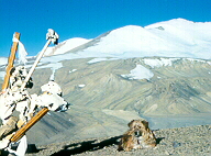
 to camp 2 was a gradual climb through scree and shrubs. Sumita and myself walked at a relaxed pace observing the birds pointed out by Jean. We knew we were one of the lucky few to have been able to come here in the first place. On the way to Saser La, Kara would often roll in the snow as if to show how happy she was to be there. On August 15 on the fiftieth anniversary of our independence we stood on Saser La (the pass of golden sands) at 5,710 metres. After a long ascent on lateral moraine and toiling up hard snow and ice slopes, we stood on one of India's windiest spots.
 every few hundred yards. There must have been remains of hundreds of animals. Surely the Yarkandis, hardy mountain people couldn't have been so careless as to get caught all the time by the winter snows? It does remain a bit of a mystery and though the bones were bleached white and antiseptic, as it were, there was a macabre quality about them. If they were Hajis returning from Mecca and got a bit too late to make it over the pass before winter, I am sure their entrance to heaven was assured."
 to Depsang La, 5,475 m from Burtse Gongma, slowly gaining altitude. Burtse is a name of a plant that grows there and can be used for firewood. A huge plateau opened out - ahead of us was a brown carpet spreading out all the way into China. Far in the distance were Remo I and II, the Saser Kangri peaks and Momotsang Kangri. It was Rakhi Purnima and the moon rose like a huge football above the ground of the camp that we were staying in.
 had seen in these six months was only a fraction of the mighty Himalayas. Tears of happiness filled our eyes as we held the Tricolour. We could see the mountains of China a few hundred feet away. Seeing the colour of the stones on the pass, I understood why the Karakoram Pass is called so, the pass of black gravel. My salute to the indomitable spirit of adventure in the form of Kara, who showed us the real meaning of companionship. It was a grand finale to a grand journey across the roof of the world.
 A satisfaction of having lived tough times. It was like the colours of the rainbow I had seen above Tso Mori lake on a rainy grey day ... merging imperceptibly, lighting up the horizon and then fading away to live on in my memory. I had discovered simple but profound truths - knowing the thin line between the possible and impossible, enjoying each moment, taking each day as it comes and leaving the rest to God, nature, Reiki, call it what you will.