| Destinations
|
|||
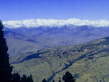
Kinnaur, the land of fairy tales and fantasies, has a spectacular terrain of lush green valleys, orchards, vineyards snow-clad peaks and cold desert mountains. The border district of Himachal Pradesh, Kinnaur is also rich in flora & fauna and its culture and language is different from other parts of the state. Kinnaur, the tribal district of Himachal Pradesh, is about 250 km away from Shimla, the capital of Himachal Pradesh and is situated on the national Highway No. 22 (Hindustan Tibet Road).
You can enter Kinnaur district at village Chora and follow a straight line road constructed in vertical rock cliff and it is a rare treat to travel on this road which is a great engineering feat. Along the road are the villages of Nigual Sarai and Bhabanagar where the famous Sanjay Vidyut power project is located. After Bhabanagar, you reach Wangtu where you cross Satluj river. From this point you can visit the famous Bhaba village and also undertake, the famous adventurous trek from Bhaba valley to Pin Valley in Spiti. |
More on Himachal • At a Glance • Chamba • Dalhousie • Dharamsala • Jwalamukhi • Mandi • Manali • Palampur • Renukaji • Sarahan • Shimla • Temples • Spiti
Travelogues Adventure • Mountaineering • Trekking • Rafting • Paragliding • Rock climbing |
||
 The road from Shimla to Kinnaur follows a scenic route running through Narkanda, famous for skiing and winter sports, where Hotel Hatu is located. Enroute are the famous apple belts of Kotgarh and Kumarsain descending to the Satluj Valley.
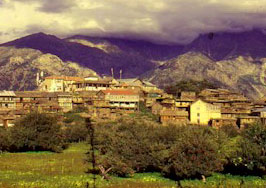
After reaching Rampur Bushahr, the famous trading town and capital of the erstwhile rulers of Bushahr State, Himachal Pradesh Tourism Development Corporation has a restaurant and bar called'Cafe Satluj'. From Rampur the beautiful village of Sarahan Bushahr is 44 km, where HPTDC has a Hotel named Srikhand. Sarahan (2165 m) is truly a heaven, tucked away in the foot hills of the Himalayas. The major attractions in Sarahan are the centuries old Bhimakali temple and the Palace of Raja Bushahr. Sarahan is also the gateway to Kinnaur.
The road from Shimla to Kinnaur follows a scenic route running through Narkanda, famous for skiing and winter sports, where Hotel Hatu is located. Enroute are the famous apple belts of Kotgarh and Kumarsain descending to the Satluj Valley.
After reaching Rampur Bushahr, the famous trading town and capital of the erstwhile rulers of Bushahr State, Himachal Pradesh Tourism Development Corporation has a restaurant and bar called'Cafe Satluj'. From Rampur the beautiful village of Sarahan Bushahr is 44 km, where HPTDC has a Hotel named Srikhand. Sarahan (2165 m) is truly a heaven, tucked away in the foot hills of the Himalayas. The major attractions in Sarahan are the centuries old Bhimakali temple and the Palace of Raja Bushahr. Sarahan is also the gateway to Kinnaur. General Information Attitude: Low and high altitude valleys from 1,000 m to about 4,000 m Climate: Very cold in winter and pleasant in summer. Being dry zone, there is no monsoon and hence ideal for visit and treks from May to November. Clothing: Heavy woollens in winter and light woollens in summer. Access Air : Shimla, nearest airport. Rail : Nearest rail heads Shimla narrow gauge Kalka broadgage. Transport Services: Buses, Jeeps and taxis are available at Shimla Rampur and Peo. Places of Tourist Interest Bhaba Valley: A beautiful valley along Bhaba river. Link road to valley originates at Wangtu. It is a beautiful landscape, reservoir lake and alpine meadows and is the best for famous trek route to Pin valley in Spiti. Karchham: The N.H. 22 that follows the old Hindustan Tibet Route goes past the villages of Jeori, Wangtu, Tapri and Karchham. Karchham (1,899 m) located at the confluence of the Satluj and Baspa rivers is the start of the picturesque Baspa or Sangla valley. Sangla: (2,880 m) The Central villages in the valley, scenic Sangla is 18 km from Karchham. A link road that goes off the N.H. into the Baspa valley offers an enchanting visit at every curve. There are saffron fields, orchards and higher up, as the road climbs the steep inclines lovely alpine meadows, Sangla is on a sharp slope with the houses rising in tiers. The Kinner Kailash peak dominates the view. From Sangla, it is possible to visit the Kamru Fort, an impressive fortress-style temple dedicated to the goddess Kali. Rakchham: (2900 m) is about 13 km on the way to Chitkul from Sangla. lt is situated on the fight bank of Baspa river and is famous for its scenic beauty. Chhitkul: (3,450 m) The last and the highest village in this valley, Chhitkul, 28 km from Sangla, is noted for its alpine meadows and snow scapes. It has a rest house. Powari: Powari, 70 km, from Rampur is the last major stop,on the N.H, 22 with a petrol station. The link road to the district Headquarters Recong Peo, takes off from Powari. Recong Peo: (2,670 m) Located 240 km from Shimla and 7 km from Powari, Recong Peo is the Head quarters of the district Kinnaur. it has a Rest House and hotels and a fine view of the Kinner Kailash. Kothi: Just 3 km from Recong Peo, Kothi has a temple dedicated to the goddess Chandika Devi. Set against a backdrop of mountains and groves of deodar the temple has an unusual architectural style and fine sculpture. An exquisite gold image of the goddess is enshrined in the sanctum.
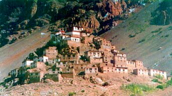
Riba: (2,745 m) Riba just (1 8 km) from Powari on N.H. 22 is famous for its vineyards and local wine "Angoori' that is made from grapes. Jangi: 26 km from Powari, the inner border is located here beyond which foreigners require permits to travel upto Tabo. From this point the famous Kinner Kailash Parikrama Trek starts touching Morang, Thangi and Kunocharang villages and entering Chitkul village in Sangla valley. Puh: (2837 m) Lush green fields, orchards of apricot vineyards and groves of almond trees, are to be seen on the route to Puh. Just 58 km from Powari along the N.H. 22, Puh has rest house and hotel facilities. Namgya: The closest village from Indo-China border, the Shipkila border point is just 13 km from this village Tashigang Gompa: This fine Buddhist Monastery is accessible from Nangya, a little diversion from Khob, located on the N.H. 22, at the confluence of the Satluj and Spiti rivers. Tilasang Monastery: The monastery is close to Koa, 12 km short of Yangthang on the N.H. 22; which has facilities for visitors to stay. Nako: (3,662 m) A little off the N.H. 22 along a link road just short of Yangthang is the scenic village of Nako the largest village in the desolate Hangrang valley. A little lake reflects the stark grandeur of the surroundings hills. Lahaul And Spiti From Nako, one reaches Sumdo, the gateway of Spiti. After crossing villages of Yangthang, Chango and Shaikhar. The exotic land of Lahaul and Spiti is a high attitude cold desert full of river valleys, high passes, snow-capped peaks, icy lakes, mighty glaciers and a tribal country-side dotted with monasteries, yaks and lamas. Spiti with a strong Buddhist tradition also known as little Tibet has nearly 30 monasteries or Gompas strung along the valley with a rich cultural heritage that is very old. Tabo: Tabo is the largest monastery complex of Buddhist religion. This has been declared as a protected monument. In June-July 1996, millennium celebrations of the monastery took place here. It has sculptures, stucco images and wall painting which are similar to the Ajanta-Alora paintings. It is situated on the left bank of Spiti river at an attitude of 3050 m. On the way to Kaza there is a bifurcation to Pin valley which is famous for its wild life and treks and is a National Wild Life Park. The valley lies on both sides of the Pin valley. Dhankar: Dhankar is situated at an altitude of 3870m, and is 23 kms from Tabo. It is one of the main villages of Spiti Valley and the erstwhile capital of Spiti state. This place is famous for it's ancient fort and monastery. Kaza: It is the head quarter of Spiti sub-division and is 47 km from Tabo. It has a Buddhist Monastery, Spiti fair is held here every year in the month of August. There is an HPTDC lodge here.
Kunzam: It is the mountain pass at an attitude of 4551 m with temple of Kunzam Devi. One can also trek from here to the famous and beautiful moon lake Chandratal (4070 m). Asia's biggest glaciers Bada and Chotta Sigri glaciers are worth seeing from here. After crossing Kunzam one reaches Batal on the right of Chandra river. After crossing Chotta and Bara Darha and Chhatry one reaches at Gramphu from where one has the option to visit Manali (84 km), Keylong (61 km) and Leh (401 km) on the highest mountain road. Note: The inner line area runs from Jangi onwards till Tabo. However, Indian Nationals do not require permfts in this area but foreigners travelling in a minimum group of four or more with pre-drawn itinerary from recognised travel agents may obtain inner line permit from RC HP Govt in Delhi or SDM, Shimla, Rampur, Kalpa, Manali and Keylong. Attractions Rivers: Satluj flowing through Namgya, Karchham, Tapri. Baspa flowing through Chitkul and Sangla. Spiti flowing through Kaza and Tabo. Chandra flowing through Batal Gramphu, Koksar and Gondla. Bhaga flowing through Keylong. Chandrabhaga flowing through Udaipur, Purthi and Kilar. Lakes: Nako, Chandratal Surajtal Fishing: Baspa river for trout. Heritage Buildings: Kamru Fort, Sangla, Moorang Fort, Gondla Fort, Gondla, Tabo, Dhankar and Key monasteries. Fairs & Festivals: Ladarcha fair (July-Aug.) Kaza, Tribal Fair (August) Keylong, Tribal Festival (Oct-Nov.) Rekongpeo Phulaich Festival Kastiar (Aug-October) Monasteries: Monasteries at Kalpa, Jhangi, Kanam, Pooh, Nako, Tabo, Dhankar, Kungri, Kaza, Kibbar, Kardang, Shehsur, Guru Ghantal near Tandi and Gamur. Temples: Baring Nag, Sangla, Chandika Devi, Kothi, Chitkulmathi (Chitkul), Mirquladevi (Udaipur) Triloknath (Trilokinath), Petrol Pumps: Rampur, Jeori, Powari, Kaza, Tandi, Keylong Airports: Shimla, Kulllu Rail Heads: Shimla Jogindernagar. Adventure Activities: River Rafting, (Spiti & Satluj rivers) Trekking, Mountaineering. Trek Options: Sarahan - Sangla (2) Sangla - Rohru over Bhuranpass (3) Kinner - Kailash from Sangla, Chitkul - Charang Thangi - Moorang (over Bhaba pass (5) Moorang Spiti Valley (over Ghunsarang pass), (6) Kaza - Mandi (over Pin Parvati pass) (7) Kaza - Key - Getelangza-Komik-Kaza (7) Kaza-Baralachapass-Keylong (8) Sangla-Badrinath (9) Jangi-Ropa (over Temtso lake).
|
|||
Editor: Romola Butalia (c) India Travelogue. All rights reserved. |
|||
 The landscape of the area varies from the lush green orchards of the scenic Sangla Valley to the stark magnificence of the Hangrang valley. The massive snow clad ranges that provide a regal dignity to the scene are dominated by the peak of Kinner Kailash, at the lap of which is located Hotel Kinner Kailash. Kalpa is one of the biggest and beautiful villages of Kinnaur district.
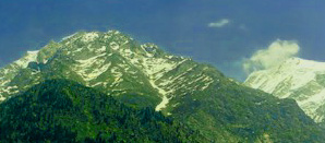
 Kalpa: (2,768 m) Beyond Recong Peo (1 4 km from Powari) on the link road, is Kalpa, the main village of the district. Across the river, facing Kalpa is the majestic spectacle of the Kinner Kailash range. They are a spectacular sight early in the morning as the rising sun touches the snowy peaks with crimson and gold light.
 Key: It Is 7 km. from Kaza and is an ancient monastery. This is situated on the hill top at an altitude of 4116 m. Kibber is the highest motorable village in the world at an altitude of 4205 m. On the way to Kunzam pass (4551m) Losa (4050m.) is the last habitated village and is 57 km. from Kaza. It has a Buddhist Gompa.