| Destinations
|
|||
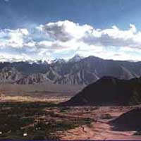
One of the most beautiful regions of Ladakh, the Suru Valley forms the mainstay of Kargil district. Lying nestled along the north-eastern foothills of the Great Himalayan Wall, it extends from Kargil town, first southward for a length of about 75 Kms upto the expanse around Panikhar, thence eastward for another stretch of nearly 65 kms upto the foot of the Penzila watershed where the Suru River rises. With its extensive tracts of alluvial floor and verdant hillsides that are intensively cultivated by a zealously agrarian peasantry, the Suru Valley serves as ladakh's granary. Its composite population of about 30,000 - mainly of Tibeto-Darad descent - are Muslims who had converted their Budhist faith around the middle of the 16th century.
The region around Panikhar and further up is a veritable valley of flowers with hundreds of varieties of wild plants blossoming to spread a riot of colours around the countryside during the months of June and July. The beauty of this region is further enhanced by the sheer contrast provided by the towering peaks of Nun (7135 m) and Kun (7035 m) which loom over the skyline in their crystaline majesty. |
More on Ladakh • Overview • Introduction • Drass • Kargil • Zanskar • Mountaineering • Ladakhis Places to Visit: • Drass • Gulmarg • Jammu • Pahalgam • Sonamarg • Srinagar • Ladakh • More on Ladakh • Travelogues • Kashmir • Journey to Ladakh
Adventure |
||
 What to see and do:
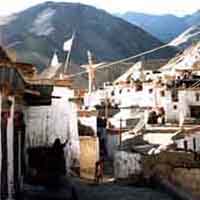
 Sankoo: A picturesque expanse surrounded by colourful rocky mountains, Sankoo is an upcoming township with a small bazar (42 kms south or Kargil) and numerous villages around. Dense plantation of poplars, willows, myricarea and wild roses fill the bowl-shaped valley, giving it the ambience of a man-made forest tucked within the mountain ramparts. Two side valleys drained by large tributary streams of the Suru river, the Kartse flowing from the east and the Nakpochu descending from the west, open up on either side of the expanse. The Kartse Valley runs deep into the eastern mountain mass with a large number of isolated villages tucked within its course. Kartse-Khar, an ancient village near the mouth of the valley, has a 7-meter tall rock sculpture of the Future Budha, evidence of the passage of Budhist missionaries through the region during the 7th/8th centuries when they travelled east of the Himalayas. The 4-day trek between Sankoo and Mulbek follows this valley; the route passes through some very beautiful alpine areas on the way to the 4950 metre high Rusi-La. The high altitude settlement of Safi with its mixed Budhist-Muslim population is stuck between the Rusi-La and the Safi-La over which the final leg of the trek passes before entering the Mulbek Valley. A southward diversion from the foot of the Rusi-La leads to Rangdum across the glaciated Rangdum Pass where the Kartse River rises. The 3-day trek to Drass across the Umba-La (3350-m) follows the western branch valley. The route of this trek passes through some very picturesque villages among which Umba is the best and highest located. During summer most of the route is found lined with colourful wild flowers.  Sankoo is very popular among local picnickers who throng the area from Kargil town and other places. Locally it is also popular as a place of pilgrimage to the ancient shrine of a Muslim scholar-saint, Sayed Mir Hashim, who was specially invited from Kashmir for imparting religious teachings ot the region's Budhist ruler, Thi-Namgyal of the Suru principality, following his conversion to Islam during the `16th century. The shrine is situated in the village of Karpo-Kharon the outskirts of Sankoo where the Chief had his summer palace. Panikhar: 67 Kms south of Kargil, Panikhar lies spread under the shadows of the Nun-Kun massif. The first full photogenic view of Mt. Nun (7135 m), however, can be had, not from Panikhar itself, but from the roadside near the village of Thangbu, about 12 kms short of Panikhar. A beautiful expanse of the Suru Valley with about dozen villages strung around, Panikhar comprises a series of intensively cultivated plateau descending in level steps from the Himalayan foothills to the bed of the Suru River that meanders along the eastern edges of the valley. During summer the area is converted into a veritable valley of flowers when an incredible variety of alpine flora blossom, lending the valley a colourful hue. Panikhar is Panikhar is also a convenient base for the famous trans-Himalayan traverse between Ladakh and the Kashmir Valley. The shorter trek to Pahalgam via the Bhotkol Pass (4420 m) in the main range of the Himalayas and the Gulol Pass connecting the Warvan and the Lidder Valleys takes about a week. If the trek to Kishtwar down the Warvan Valley, or to Lehinvan in the Kashmir Valley across the Margan Pass takes longer. All these routes follow the Chelong Valley upto the main wall of the Great Himalayas where the Bhotkol Pass gives access to the headwaters of the Warven Valley across. Local petty traders still use this route and so do the Bakkarval herdsmen in summer. Till recently the Bhotkol Pass served as an important trade link between the Suru Valley and Kashmir or Kishtwar. The Panikhar area is quite popular among several North-Indian universities for conducting field studies in various disciplines of the sciences. It is also very popular as a picnic or excursion station. Among the local attractions the most important ones are the architectural beauty of the two mosques at Taisuru, the village across Panikhar. Rangdum (3657 m): The farthest and most isolated part of the Suru Valley, Rangdum is an elliptically expanded plateau surrounded by colourful hills on the one side and glacier-encrusted rocky mountains on the other. Situated 130 kms South-east of Kargil, it falls midway between Kargil and Padum. Visitors to Zanskar generally prefer to break the gruelling, 240 Km-long rough road journey for an overnight halt here. Set amidst spectacular surroundings, Rangdum serves as the ideal area for camping in the Himalayan wilderness while being sufficiently near a road head. Due to its remoteness from the inhabited parts either of Suru or Zanskar, the area's wild beauty is almost haunting, while its isolation is near perfect even as the unpaved Zanskar road traverses its length. In the late afternoon the setting sun leads the Valley an ethereal ambience as the ochre hills turn aflame while the snow-covered peaks sparkle with a reddish hue in the distant horizon, contrasting beautifully with the surrounding rocky mountains. The chief attraction of the area is an imposing 18th century Budhist monastery with about 40 monks in residence. Perched picturesquely atop a centrally rising hillock which is entrenched around by the bifurcated course of a wild mountain stream, the Rangdum monastery has the aura of an ancient fortification guarding a mystical mountain valley. Its central prayer hall houses an array of Budhist figures and art objects, some being huge and imposing, others small but exquisite. Two small hamlets surrounded by rows of chortens, one each on either end of the Valley, are the only habitations in the area besides the monastery. The villagers are descendants of the monastery's agricultural serf-tenants, who do not own any land in the region. The monastery enjoys perpetual and unalienable ownership of the entire valley, including the fields tilled by the villagers, the pastures, hills and even the streams. Rangdum also serves as an important trekking base. The most popular trek from here leads to Henaskut near Lamayuru, across the spectacular gorge of the Kanji Valley. This 5-day trek also forms the last leg of the 2-week long trans-Himalayan traverse between Kashmir and Ladakh. A more adventurous trek from here leads to Kishtwar via the glaciated Valley - a virtual circumambulation of the Nun-Kun massif. Among the shorter treks available, the best is a hike up the Penzila Ridge to camp for a night or two opposite the majestic Drang-Drung Glacier. This rather easy walk offers breathtaking views of the Great Himalayas towards the West. The trek to Shafat Valley where the Nun-Kun base camp is situated, involves walking down valley along the road to Gulmatongo (20 kms), thence fording the Suru river on horse back to enter the Shafat Nallah upto the snout of the Shafat Glacier for camping. A foot bridge is ready for launching on the Suru for this approach. Other much shorter, day-return hikes are aplenty around the area. How to reach: Sankoo, Panikhar and Parkachik are connected with Kargil by regular bus services, in summer even twice a day. The bus ride from Kargil takes 2 hours to Sankoo, 3 hours to Panikhar and about 4 hours to Parkachik. Rangdum is serviced by the bi-weekly bus service to Padum which increases according to demand. Some trucks plying between Kargil and Padum also offer a lift in the cabin for the price of a bus seat. Cars and jeeps taxis can be hired from Kargil for visiting different places in the Suru Valley, including Rangdum and Penzila. Information: Courtesy Govt of India |
|||
Editor: Romola Butalia (c) India Travelogue. All rights reserved. |
|||
 The upper reaches of the Valley, particularly around the Sankoo bowl, the Panikhar expanse and the higher stretch beyond, present a spectacle of breathtaking features-majestic mountain ramparts crowned by snowcapped peaks, undulating alpine slopes draining into wild mountain streams of foaming cascades of pristine water, awesome glaciers descending along the Himalayan slopes to the river bed in riverine formation, quaint villages of adobe houses straggling dry hillocks surrounded by large tracts of lush crops downward and patches of alpine pastures uphill.
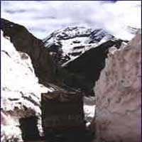 the base station for undertaking mountaineering expeditions to the various Himalayan peaks surrounding the valley. Tangol, the approach base for climbing Mt. Nun, is just 6 kms further up the valley on the road side. A short walk up the hill slopes from here takes one across the Sentik ridge to the base camp on the rim of the ice plateau. Another very interesting hike is to the Nun-Kun view saddle (3810 m) in the Parkachik ridge which requires 3 hours of walking up along verdant slopes overlooking the fertile valley below. From the top of the picturesque saddle one can have a panoramic view of all the peak in the Nun-Kun mass if besides its vast glacial plateau. From here one can retrace the way back to Panikhar in half the time, or descend to the Parkachik ravine across the ridge to camp near the village. Near Parkachik is the majestic Parkachik Glacier spilling down a lateral ravine in the Nun-Kun slopes to collapse into the Suru River forming a huge ice fall. One can walk upto the glacier across a good suspension foot bridge over the Suru. Some mountaineers use the glacier to approach the difficult north face route to Mt. Nun. If one wanted to experience the ultimate thrill of camping under the very crest of the Great Himalayan Range, yet not without the safety of instant communication nearby, the upper Suru Valley around Tangol and Parkachik may well conform to his idea of such an area.