| Destinations
|
|||||||||||||||
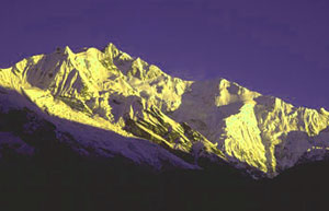
Sikkim is a small stretch of rugged land just 115 km by 65 km sandwiched between the Kingdom of Nepal in the West where the Singalila Ridge forms a natural border and the Kingdom of Bhutan in the East. Towards its Northern border is the plateau of Tibet whereas in the South, the Tista and Rangit rivers form a natural boundary with the Indian state of West Bengal. On the world map, Sikkim is just a speck at the latitude of 27 degrees North and longitude of 88 degrees East. Its size belies the richness of culture, customs, heritage, flora and fauna. In this small area of just 7,096 sq km - only slightly bigger than that of Delhi and its suburb towns - are wild animals like mongoose and the endangered red panda and a wide range of flora from primulas to the magnolia. The customs and cultures of the different communities that reside here also present a kaleidoscopic picture. From the plains, a mere 80 kms as the crow flies, the altitude soars to pinnacle at 28,168 feet at the very top of Khangchendzonga, the third highest peak in the world. Such a sharp elevation is unrivalled anywhere else. Nowhere else do so many 7,000 metre plus peaks neighbour each other in close proximity. The sharp gradation has created the most variegated flora and fauna possible anywhere in the mountains. Moreover, the climate ranges from the sultry tropical to the cold arctic type. What makes Sikkim even more attractive is the sparse permanent population and relatively few travellers by virtue of its remote far-Eastern Himalayan location. |
More about Sikkim • An Overview • History • People & Culture • Economy • Festivals • Off the Beaten Track • Wild Life • Adventure • Monastery Magic • Gangtok • Tourist Information • Accommodation • Getting There • Climate • FAQ
Travelogues
Trekking
| ||||||||||||||
The highest portion of Sikkim lies in its North-West direction. A large number of mountains having altitudes of seven thousand metres stand here with Khangchendzonga (8,598 m.), the third highest peak in the world. The high serrated, snow capped spurs and peaks of Khangchendzonga consist of Kumbha Karna (7,711 m.), Pendem (6,706 m.), Narsingh (5,825 m.), Kabru Dome (6,545 m.) and others.  The Tista is the main river of Sikkim with its chief tributaries being Zemu, Lachung, Rangyong, Dikchu, Rongli, Rangpo and Rangit, which form the main channel of drainage from the north to the south. It boasts of the great mount Khangchendzonga as its crowning glory. Ethnically, Sikkim has three main communities : Nepalis, Bhutias, Lepchas. The local language is Nepali. English is the official language. Administratively, Sikkim has been divided into four districts and each district has further been bifurcated into two sub-divisions.
The two mountain ranges that form an almost impregnable barrier are: Singalila: on the Western border 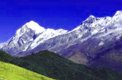 Chola: on the Eastern border
Glaciers:
Glaciers are moving mountains of ice, which are found in plenty in Sikkim. The Zemu glacier is situated in a large U-shaped valley at the base of the Khangchendzonga massif in NorthWestern Sikkim. It has a length of about 26 km and is the largest and best known glacier of the Eastern Himalayas. The River Tista rises from the snout of this glacier. Many tributary glaciers feed the trunk glacier. The side valleys in which these glaciers lie, open into the main Zemu Valley from different directions. Icefalls and waterfalls have formed at the junction of the Zemu glacier with tributary glaciers.
The Rangeet river originates from the Rathong Glacier. Passes: The mountain ranges are interspersed with passes, which are used to cross from one mountain to another. On the Eastern Chola range, the most important passes are the Nathu La and Jelep La, both at altitudes of about 15,0000 ft. The Bhutah La is at an altitude of about 13,000 ft. The first two lead to Tibet and the third to Bhutan. On the West border of Sikkim and Nepal, the most important pass is Chiwabhangjang, which is at an altitude of 10,300 ft. The other pass on the West is Kang La. In the North, one of the important passes is the Kongra La. Vegetation: About one-third of Sikkim is forested. Sal, pandanus, palms, bamboos, ferns, and orchids (660 varieties are known to be found in Sikkim) are common in the subtropical forests found below 5,000 feet. In the temperate forests (5,000 to 13,000 feet), oak, laurel, maple, chestnut, magnolia, alder, birch, rhododendron, fir, hemlock, and spruce predominate. Alpine tundra replaces forest at the higher elevations. The cardamom spice is a cash crop that grows wild extensively around Yuksum and Phodang. Needless to say, agriculture in this state is literally an uphill task.
Compiled by Romola Butalia
|
|||||||||||||||
Editor: Romola Butalia (c) India Travelogue. All rights reserved. |
|||||||||||||||
 A number of glaciers descend from the eastern slopes of Khangchendzonga into Sikkim. The largest of them is Zemu, from whose snout, above Lachen monastery, arises the river Tista.