| Trekking Kinnaur Kailash Parikrama |
|||||
The Kinnaur Kailash Parikrama is not a very popular trek, at least compared to some of the trekking routes in the Garhwal Himalayas. I had heard about this trek after I went on the Kailash Manasarovar Yatra in 1996. I gathered that there are three peaks called Kailash in the Himalayas. Kailash in Tibet, Chota Kailash in Uttaranchal and Kinnaur Kailash (19,844 feet) in Himachal. To go to Chota Kailash one has to trek on the same route that goes to Tibet for Kailash and Manasarovar. From the roadhead at Dharchula one has to trek for 6 days to reach Gunji. At Gunji the route bifurcates. Kailash - Manasarovar yatris take the route north, trekking another 3 days to reach Tibet after crossing Lipulekh pass. The bifurcation from Gunji goes further west to Joalingkong (18 Kms) and finally to Chota Kailash and Parvati Tal. Kumaon Mandal Vikas Nigam organises regular treks to Chota Kailash. I came back from Kailash Manasarovar Yatra with high hopes of going to Chota Kailash the very next year. Back in the plains, I realised that plans and promises made during high altitude treks are often not fulfilled. Fellow yatris who promised to meet at Almora at the same time following year had simply vanished or were otherwise busy and my desire remained in my mind only. Subsequent years saw me on various other trekking routes but not the one to Chota Kailash. I did entertain the idea of doing a solo trek, but the hope of doing it someday with fellow yatris kept me from further pursuing the matter. |
More About Himachal • An Overview
Trekking
Pilgrimage
Travelogues
Adventure activities | ||||
Kinnaur Kailash had simply faded from my memory until 2001 when someone suggested the trek. 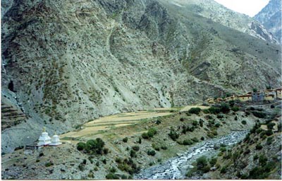 I searched the Internet for details about the trek but found no leads other than ads from Delhi based travel agents quoting in Euros. All the information I could find indicated Kalpa in Kinnaur district as the place to start the trek and finally on 5th September I left Kolkata for Delhi. Tired after a hard day at the office winding up my work, I boarded the Delhi bound evening flight. I reached Old Delhi station just in time to catch the Kalka Mail. The train was on time and when I disembarked at Kalka station, I hired a car to take me to Kalpa. After a nights halt at beautiful Sarahan (6298 feet) in HPTDC's tourist lodge near the 800 years old Bhimkali temple I left, early in the morning for Kalpa (9708 feet). The journey from Kalka to Kalpa is anything but pleasant. The landslide prone road, NH22, runs by the side of the Sutlej river after coming down from Narkanda (8882 feet). With large stretches remaining unmetalled and unbearably dusty due to frequent landslides, one has the feeling that one is driving on a wide trekking route. I searched the Internet for details about the trek but found no leads other than ads from Delhi based travel agents quoting in Euros. All the information I could find indicated Kalpa in Kinnaur district as the place to start the trek and finally on 5th September I left Kolkata for Delhi. Tired after a hard day at the office winding up my work, I boarded the Delhi bound evening flight. I reached Old Delhi station just in time to catch the Kalka Mail. The train was on time and when I disembarked at Kalka station, I hired a car to take me to Kalpa. After a nights halt at beautiful Sarahan (6298 feet) in HPTDC's tourist lodge near the 800 years old Bhimkali temple I left, early in the morning for Kalpa (9708 feet). The journey from Kalka to Kalpa is anything but pleasant. The landslide prone road, NH22, runs by the side of the Sutlej river after coming down from Narkanda (8882 feet). With large stretches remaining unmetalled and unbearably dusty due to frequent landslides, one has the feeling that one is driving on a wide trekking route.
The information on the net turned out to be wrong.
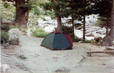
9th September, Thangi to Lambar (9498 ft; distance: 12 Kms): We started around 6 in the morning from Thangi. The route was fairly easy, a gradual climb through a path which is soon slated to become a motorable road. Few kilometers out of Thangi the path ended and Anant Singh directed me towards the cliff side. A path was visible by the side of the river about 300 feet down. We made our way through a rock fall to come down almost to the bed of the river. The path then followed the river till Lambar, which according to the map is actually lower than Thangi. There is an ITBP camp at Lambar with 2 men sharing a small cottage. They were very happy to see us and immediately offered their room for the nights stay. The Lamber camping ground was by the side of the river and looked so tempting that I decided to pitch my tent instead of taking up the ITBP offer. In the afternoon I went up to the village, situated higher up on the rock face. There were apple orchards everywhere and a local man invited me to join him as he took a tour of his orchard. He showed me the various varieties of apple and stuffed my backpack with enough apples to last me the trek.
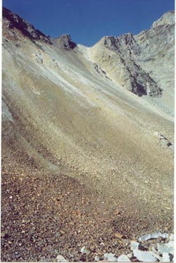
10th September, Lambar to Charang (11500 feet; distance: 22 Kms): 11th September, Charang to Lalanti (14501 feet; distance: 15 Kms) Blissfully ignorant of the tragedy that had shocked the world, we started around 6 in the morning for Lalanti aware that we would have to cross a pass above 15,000 feet. The climb along a well-marked path is tedious but gradual. The views from the top are superb and we stopped for breakfast. From the top one can see the small village of Kunnu which is a detour from Lambar and Charang. In the distance, peaks bordering Tibet can also be seen. The path after the pass is extremely difficult and hazardously narrow to maneuver. After a while the path eases and we followed the Lalanti Gad river to a trekkers hut at Lalanti. The hut is on the other side of the river and we had to wade barefeet across several streams before reaching the spot. The hut is poorly maintained and it is difficult to find a place to spread your sleeping bag. We opted to pitch our tent in a nearby clearing. Vegetation is sparse in Lalanti. On the right, the river bed rises to the glacier point on Charang La pass (17,194 feet). The sky was cloudy and we were treated to some mind-blowing colours of the sunset. 12th September, Lalanti to Charang La base camp 13th September, Charang La base camp to Chitkul (11316 feet; distance: 8 Kms): The morning was clear. After crossing several streams we started our climb for the pass. There is no path and we climbed through glacial moraine, at times on all fours. The last few steps to the top was killing. Gasping for breath in the rarefied air we reached the top of the pass around 10:30am. The views on the other side were superb. A steep fall eases out to the lush green Baspa valley. The river could be seen cascading down the mountain. We could not stay longer. The narrowness of the ridge, strong winds and steep descent ahead made us well aware that this was not a place to hang around. We reached Chitkul late in the evening returning to civilisation and a well-earned hot bath.
|
|||||
Editor: Romola Butalia (c) India Travelogue. All rights reserved. |
|||||
 Kalpa used to be the district headquarters of Kinnaur district but now it was an almost deserted town with Recong Peo as the new headquarters. People were mildly surprised at the mention of the Kinnaur Kailash parikrama. No one was able to offer any assistance with regard to possible porters, but suggested that I go to Thangi (9728 ft) and try there. Next morning, a 50 km bone-jarring ride saw me at Thangi, the road head. Thangi is an incredibly beautiful place, situated high above a deep gorge, with the old village perched even higher and looking extremely picturesque. A grocery shop became my shelter for the night and the owner promised to get a porter for me by evening. After lunch I was sitting in front of the store when the owner came with a man in tow. Anant Singh was originally from Nepal and arrived here every year during the apple plucking season. He claimed to know the route and asked for Rs. 200/- per day.
 The trek to Charang follows the river and is mostly along the riverbed. It is a long trek but not difficult. Halfway there is an ITBP camp where you are supposed to register your name before proceeding further. A permit is also needed from the District Commissioner of Recong Peo. I was not aware of this and it was too late to rectify the matter. The ITBP guys didn't stop us. We reached Charang late in the afternoon. There is a PWD rest house overlooking the beautiful village situated on top of a ridge. The rest house has beds, a fully equipped kitchen and most importantly, a toilet with running water. After lunch we went to the 400 year old Charang Devi temple after a 45 minute steep climb. Charang is the last village on this side of the Indo - Tibet border.
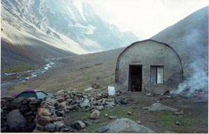 (about 15,000 feet; distance: 6 Kms): There is no path but an endless boulder hopping. Hardy trekkers can think of going all the way to Chitkul after crossing the pass but by the time I reached the base of the pass I was so tired that I decided to rest for the night and start next morning for Chitkul. The sky was already dark by the time our tent was rigged. The winds were blowing at hurricane speed and soon it had started snowing. The stark landscape was beautiful indeed, but the weather drove us hurriedly into the shelter of the tent. The night was bitterly cold and I shivered uncontrollably without getting much sleep.