| Trekking
Kalindi Khal- Pinnacle of Trekking |
||||||||
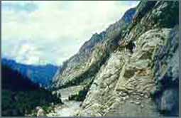
In the blistering heat of June 1996, we left Calcutta for Uttarakashi, stopping briefly at Haridwar and Rishikesh. To my mind, Uttarkashi is synonymous with the excitement that comes with the preparation stages of a trek. A couple of days were spent on formalities like the necessary innerline permits for trekkers and porters before we left for Gangotri. There was guide Raju, cook Bharat, and Ratan and Ram Singh, my old trusted guide-cum-porters from Joshimath. Our group had six members, three were somewhat new to trekking but compensated with enough enthusiasm to bridge the gap. Gangotri has changed since my first visit there in 1948 when the motor road stopped at Harsil. In those days, at Gangotri there was only the temple and the Kali Kamli Ashram. There was neither electricity, nor blaring music, just the river and a handful of tired pilgrims. Few would venture towards Gaumukh. Without even a trekking trail, one had to follow the river and boulder hop one's way till Lal Baba's small rest shed where cups of tea were always available for the tired pilgrim. Gaumukh has since receded by 3 Kms. |
More on Uttarakhand • Overview • Char Dham
Trekking
Travelogues
Impressions
Adventure activities | |||||||
The next day we climbed briskly to Gaumukh, from where, after a brief rest, we began our ascent towards Nandanvan along the left side of Gangotri glacier. Here, the massive rock fall area is in a state of perpetual action, but fortunately it remained quiet during our crossing. After about an hour, we saw Raktavarna glacier. The reddish colour of the boulders was in startling contrast to the pure white expanse of Gangotri glacier. In the meantime, the weather was closing in and our ascent across giant boulders was becoming increasingly tiring. After noon we could see Chaturangi Glacier. We crossed the confluence of the three glaciers with the prospect of a steep climb ahead of us. Climbing through a steady drizzle we reached Nandanvan in the late afternoon. Most of the group were too tired to enjoy the stark beauty of dark clouds looming overhead blocking views to all the majestic peaks that surrounded us. We particularly missed the sight of Shivlinga, undeniably one of the most beautiful peaks in the Himalayas. It was soon snowing and we hurriedly dived into the hastily pitched tents. 
The next morning, though it was not snowing, the sky was overcast with gloom. After about an hour we reached Chaturangi Glacier, ahead of which was the confluence with Vasuki glacier. The physical changes that have taken place in this part of the Himalayas are amazing, perhaps nature has a way of making trekking routes more challenging as man's quest for the unreachable increases. What used to be a simple crossing of Vasuki Glacier to climb a ridge to reach Vasuki Tal (4898m), now involves traversing the Chaturangi glacier with a challenging crossing of the crevasse-filled Vasuki Glacier by cutting steps in the rocklike ice.
We sat in the grassy knoll enjoying the beauty and the grandeur of the Himalayas. On the south rose the Vasuki peak (6790m) while the placid waters of Vasuki Tal reflected the towering Bhagirathi peaks. I recalled an earlier time when we had bathed in the waist-deep waters of the lake. Now there was a mere patch of damp grass and some accumulated water. The architect that caused the change was nature itself, having created a drainage point for the water to flow downwards.
On 3rd July, after a brief climb of 15 minutes to come to the side of Chaturangi Glacier, surrounded by mighty peaks on all sides, the cloudless sky gave an ethereal feeling. Sundar Glacier soon came into view. The crossing was much like that of Vasuki Glacier and we climbed a wall to reach Khara Patthar (5104m), named after the sheer rock face of the slope.
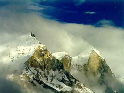
We got up to a depressing morning, with visibility down to the level of 'whiteout' because of the snowfall. We had to cross Chaturangi glacier for the last time to reach Sweta glacier. The weather worsened with knee-deep snow, zero visibility and the eerie feeling that a crevasse awaits the very next step. Finally around 3 pm we reached the base of Kalindi. I was deeply concerned with the weather condition, keenly aware that the path ahead passes beside an avalanche prone zone and unless visibility improved, we were in acute danger. What I recall of those hours is simply the relief of being in our sleeping bags by 7 p.m. Sometime during the night, the snowfall had abated. At 3 am we emerged from our tents to a clear sky. Ahead of our camp lay Kalindi and Avalanche peaks. We would have to cross the slope between the peaks. Starting at 6:30 am. an hour later we came on the slopes of the col. An icefall lay about 200 meters ahead. Our progress was halted by an earth shattering noise and we watched an avalanche coming down the slopes of Avalanche peak. Our guide insisted that we cross this region as quickly as possible. Easier said than done at 19,000 feet.
|
||||||||
Editor: Romola Butalia (c) India Travelogue. All rights reserved. |
||||||||
 From Gangotri, we left for Nandanvan via Bhojbasa on 29th June. We started around 8 am and were at Bhojbasa at lunch time. We halted in the shelter of a tin shed beyond Lal Baba's Ashram, which has expanded since my early visits to the area.
 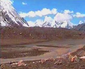 The snow continued to fall through the night, with no sign of abating in the morning. We decided to stay at Nandanvan for the day. At noon when the snowfall stopped, we came out of our tents but the cloud cover showed no signs of lifting.
 Once across, we were confronted by a steep wall. Ropes were fixed and one by one we all came up on the ridge. Vasuki Tal lay below us. Compared to some other lakes in the Himalayas, this is merely a dent on the rock where water has accumulated but the beauty of the surroundings more than compensates the size of the lake. Our cook, Bharat took all of us to a sheltered deity on the rock face where we offered Puja. At these altitudes one tends to believe anything. On cue, the sky cleared and after three days the weather turned and we were blessed with brilliant sunshine.
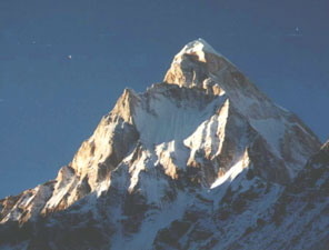 The next day no one seemed in any mood to trek, but this was hardly the appropraite place to hang around. Ahead was Suraloy glacier, which takes the trophy in terms of danger and difficulty. The route is an endless ice field with gaping glaciers breaking the monotony of the landscape. Encouragement comes in the form of the towering peaks of Satopanth (7075m), Chandra (6739m) and others. That day's trek was so exhausting that we had to halt 2 kms before our scheduled camp at Sweta glacier. The place was near the base of Chandra Parvat, strewn with boulders. Somehow a patch was cleared for pitching tents. The views of Chandra Parvat from the campsite defy description. I sat till late in the night on a boulder looking at the peak. A group member came out of his tent and almost mistook me to be a yeti!