| Destinations
|
|||||||||||||||
Location Jammu and Kashmir has an area of 22.2 lakh sq. kms and a
population of 77.2 lacs. The state has its summer and winter
capitals at Srinagar and Jammu, respectively. Kashmir's
population is predominantly Muslim, with a rich Islamic
history that can be traced back to the 14th century. South of
the Kashmir valley is the region of Jammu situated on the
North Indian Plains, close to the Shiwalik hills. North of the
Shiwaliks, the rest of the Jammu region is drained by the
Chenab river whose vast catchment area includes several narrow
valleys that extend deep into the high Himalaya. The region of
Jammu is predominantly Hindu, although there are small Muslim
communities in the vicinity of Banihal and Kishtwar
immediately south of the Kashmir valley.
Besides the cities of Jammu and Srinagar, other important
towns are the district headquarters of Anantnag, Pulwama,
Budgam, Baramulla, Kupwara, Udhampur, Kathua, Rajouri, Poonch,
Doda, Leh and Kargil. The remaining towns continue to have
many rural features and pursuits reflecting the state's
predominant agro-pastoral economy.
|
More on Kashmir • Overview • History • People • Economy • Festivals • Wildlife • Adventure • Tourist Information • Climate Places to Visit • Drass • Gulmarg • Jammu • Pahalgam • Sonamarg • Srinagar • Ladakh • More on Ladakh • Pilgrim Places • Amarnath Yatra • Vaishno Devi Travelogues • Kashmir • Journey to Ladakh
Adventure |
||||||||||||||
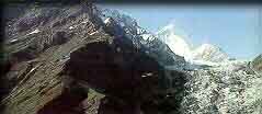
The great Himalaya range is the main mountain divide between the region of Kashmir and Ladakh. In Kashmir, it extends southeast from the vicinity of the Zoji La. It includes Nun and Kun, the two highest peaks in the West Himalayas. The Pir Panjal range encloses the valley to the west and the south, rising on average to elevations of around 5,000 m. To the north, the North Sonamarg Range provides an equally impressive backdrop, including the sacred peak of Harimukh. To the east the Amarnath and Kalohi ranges rise above Sonamarg and Pahalgam.  Besides many lofty mountain ranges, the area also abounds in lakes, passes, glaciers, plateaus and plains. There are many low lying valleys in the state like Tawi Valley, Chenab Valley, Poonch Valley, Sind Valley and Lidder Valley, but the main Valley is the valley of Kashmir, which is 100 km wide and 15,520.3 sq. km in area and is lined by 12,000-16,000-ft-high mountains that help shelter it from the wet southwest monsoon. A number of streams, brooks, hill torrents and rivers which include Indus, Chenab, Jhelum and Ravi flow through this area. Rising from a deep spring at Vernag, the Jhelum meanders northwest from the northern slope of the Pir Panjal Range through the Vale of Kashmir to Wular Lake, which controls its flow. Emerging from the lake, the Jhelum crosses the Pir Panjal in a 7,000 ft (2,100 metre) gorge en route to the Indus river. The total length of the Jhelum is about 450 miles (725 km).
In Jammu, the thorny bushes of the arid plains contrast with the alpine flora of the higher altitudes. Trees include maple, horse chestnuts, silver fir, birch, rhododendron, berbers and a large number of herbal plants in the higher altitudes. The most magnificent of the Kashmir trees is the gigantically sized chinar found throughout the valley. The colours in which the tree presents itself through the cycle of the seasons is enchanting. Mountain ranges in Kashmir have dense growths of deodar, pine and fir. Walnut, willow, almond and cider also add to the rich flora of Kashmir. Compiled by Puneet Sachdeva |
|||||||||||||||
Editor: Romola Butalia (c) India Travelogue. All rights reserved. |
|||||||||||||||
 Strategically located at the northern most extremity of India,
the state of Jammu and Kashmir comprising the areas of Jammu,
Kashmir and Ladakh appears as a crown on the map of India. To
its north is China and Russian Turkistan. On its east is
Chinese Tibet. On the South and Southwest lie the Indian
states of Punjab and Himachal Pradesh. On the west is the
North West Frontier Provinces of Pakistan. 640 km in length
from north to south and 480 km from east to west, the state is
situated between 32.17 degree and 36.58 degree north latitude
and 73.26 degree and 80.30 degree east longitude
Strategically located at the northern most extremity of India,
the state of Jammu and Kashmir comprising the areas of Jammu,
Kashmir and Ladakh appears as a crown on the map of India. To
its north is China and Russian Turkistan. On its east is
Chinese Tibet. On the South and Southwest lie the Indian
states of Punjab and Himachal Pradesh. On the west is the
North West Frontier Provinces of Pakistan. 640 km in length
from north to south and 480 km from east to west, the state is
situated between 32.17 degree and 36.58 degree north latitude
and 73.26 degree and 80.30 degree east longitude
 The state comprises four geographical zones of kandi or dry
belt; the Shiwalik ranges; the high mountain zone constituting
the Kashmir Valley, Pir Panjal range and its off-shoots
including Doda, Poonch, Rajouri and parts of Kathua and
Udhampur districts; and the middle run of the Indus river
comprising Leh and Kargil.
The state comprises four geographical zones of kandi or dry
belt; the Shiwalik ranges; the high mountain zone constituting
the Kashmir Valley, Pir Panjal range and its off-shoots
including Doda, Poonch, Rajouri and parts of Kathua and
Udhampur districts; and the middle run of the Indus river
comprising Leh and Kargil.