|
Travelogues Manali to Leh
|
|||||||||||||||||||||
Manali in Himachal Pradesh is the roadhead for the trans-Himalayan highway for the near-legendary two-day journey to Ladakh's capital, Leh. After visiting other places around Manali, we got into a bus to Leh, Ladakh at 6 a.m. We were surprised to see that we were the only Indian tourists on the bus. Later when we realised that we were the only Indian tourists in Leh, we felt like crying at so much unappreciated beauty. |
More About Himachal • At a Glance
Travelogues Trekking • Manali to Leh | ||||||||||||||||||||

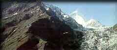
Rohtang La (La means "Pass" in Tibetan) is the gateway to the rugged regions of Lahaul and Spiti. The pass between two 5,000-meter peaks, is one of the most treacherous passes in the region. People have been stranded there sometimes due to the sudden deterioration of weather. Rohtang literally means "pile of dead bodies". The descent from Rohtang to the floor of the Chandra Valley affords tantalizing glimpses of the shining white sail massif. Koksar is where the road finally reaches the river. I can't forget the parathas we had there. They were aaloo-stuffed parathas, deep fried, yet not oozing oil, served with a Tibetan chutney. Finger-licking irresistible!
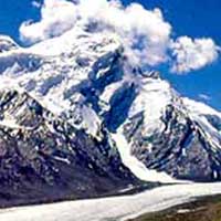
You head to Lachlang La (5,059m) from Sarchu, the second highest pass on the highway, before descending to Pang at 4,500m. 3 km from Pang is the extraordinary Moray Plains (4,800m), a 45-kilometre-long plateau encircled by rolling hills and brilliant white Himalayan peaks. The road starts its ascent from Dibring Camp to Tanglang La at a head-spinning 5,328m. This is the second highest pass in the world and by the time you reach there, your nose might well start bleeding slightly. This is a symptom of altitude-sickness. (More about this later). The Karakoram range of the Himalayas, visible from here signals that you are approaching Ladakh. This road goes along our age-old Indus (Sindhu) valley. Sindhu is the river which was the lifeline of India for thousands of years. It fed one of the oldest civilizations of the world (Indus Valley civilization). It is natural to feel overwhelmed at the sight of this great river.
The Gateway to Ladakh from Manali is Upshi. This is where the project for constructing and maintaining the highway, undertaken by the Indian army concludes. Considering the rugged terrain of the mighty Himalayas, maintaining this road itself is a Herculean task. Project Himank, as it is called, is amazing. One roadside board read, "If you want a road to the moon, please contact Himank". And we didn't find any exaggeration in it! On the way from Upshi to Leh (40kms) there are high peaks crowned with village houses and gompas. Gompas are Buddhist monasteries, ranging from solid stone structures to fairly large temples. The first impression of Leh was that of a desert with green patches fed by the Indus. One of the first things you notice are the prayer wheels with ringing bells. As Leh is 3,505 m above sea level, most tourists experience a degree of altitude sickness. The symptoms are persistent headaches, dizziness, drowsiness, bleeding and blocked nose, and/or shortness of breath. It is because your body has not yet acclimatized to the comparative lack of oxygen. So the tourism department suggests you take complete rest for at least 48 hours. Since we couldn't afford so much rest, we had to make do with 24-hours rest, before venturing out. As we had not booked any accommodation in advance, we went to several hotels/guest houses. Many of them were full. Even before we had walked half-a-kilometer, we were exhausted. Most of the family-run guest houses are managed by women, who were so apologetic that they had no rooms! They greeted us with a sweet "Julay" (Ladakhi "namaste"), and even offered us tea. Leh, the Ladakhi capital, sprawls from the foot of a ruined Tibetan-style palace - a maze of mud-brick and concrete. Leh only became the regional capital in the seventeenth century, when Sengge Namgyal shifted his court here from Shey, 15 km southeast, to be closer to the head of the Khardung La-Karakoram corridor into China. (Khardung La is the world's highest pass, 39 kms from Leh). Predominantly Buddist, Leh has 25% Muslim population.These are Ladakhi Muslims, with their own cultural heritage, quite distinct from elsewhere.
The power situation in Leh is very bad. Much of the time, including the nights, there was no power at all. That forced us to have many candlelit dinners. Telephone connection is through satellite. In the evenings, it is very difficult to get connected by telephone to the rest of India. Since Leh is cut-off from the world for around 8 months each year, they have to get most of the necessary cargo (like building materials, etc) during the 3-months' season. The only solace is that they are connected by air almost throughout the year. But the villages on the Manali-Leh highway remain completely isolated for 8-9 months a year. If only there were more time to explore Ladakh as it deserves to be. The spectacular Zanskar valley, the blue-green Pangong Tso (Lake), the 7,000m Nun peak . We resolved to return to Ladakh as trekkers.
|
|||||||||||||||||||||
Editor: Romola Butalia (c) India Travelogue. All rights reserved. |
|||||||||||||||||||||
 From Manali, the road crosses the Beas to begin its long ascent of the Rohtang Pass (3,900m). The views over the eternal snows of Solang Nala improve as you progress up, ranging from the coniferous forests to grassy mountain pastures. Just below the pass, the bus stops for a breakfast halt beside some dhabas. Nearby, a temple crowns the top of a bluff from where you get a great panoramic view of the upper Beas Valley.
 From Darcha, the road climbs steadily along the mountain side of wine-red and pale-green scree to Zingzing Bar. As you move from this desolate land, you approach Baralacha La, which will blow your mind. The "twelve-horned" pass forms the head of three valleys, the Bhaga, the Chandra, and the Yunan. By the time you get to Sarchu Serai you'll be ready for a night's rest, which is in a tent. This is in the plains next to Bagha river at the bottom of a high, straight peak. Some makeshift dhabas serve you dal-chawal for dinner. At 4:30 a.m. you will be woken up to continue the onward journey at 5. Even with the protection of many layers of warm clothes, the shivering does not stop.
 I started sipping the tea; it was bitter, so I told him the tea was not good here anyway. He suggested more sugar in the tea, and I did exactly that. I probably took a few more sips of the tea, and that's all I remembered.
 Ladakh is a trekkers' paradise. Foreigners move around with their backpacks, heading in different directions. Attractions in and around the town itself include the former palace and Namgyal Tsemo gompa. A short walk across the fields, the small monastery at Sankar harbours accomplished modern tantric murals and a thousand-headed Avalokitesvara deity. Among the string of picturesque villages and gompas within reach by bus are Shey, site of a derelict seventeenth-century palace, the spectacular Tikse gompa and the Hemis gompa, the largest in the region. Tikse has a huge statue of the sitting Buddha.