| Trekking
Charang La, Kinnaur |
|||||
Lonely Planet's Trekking in Indian Himalaya, the Bible for trekkers, classifies it as a demanding trek (other classifications being easy and moderate). It is also one of the five treks in the Indian Himalayas that crosses the 5000 metre altitude mark: all the others are in Ladakh. Charang La. The Tibetan-sounding name sets off a gong in the mind. It is also the parikrama route for Mount Kinner Kailash (6050 m, or 19,844 ft) in Kinnaur, Himachal Pradesh. Different sources suggest different periods to do this trek - though most state July-September as the best. Our group of three (from the intended eight) decides to go in mid-June. If the locals use it around this time, so can we, goes the illogical decision. The fewer the better, advises the person we hired out equipment from, in Delhi. A four-man tent, sleeping bags and mats, and rucksacks hired, we stuff our rations, munchies, glucose, medicines and personal effects into rucksacks and head for ISBT. The Himachal Roadways 8.30 pm bus departs bang on time. |
More About Himachal • An Overview
Trekking
Travelogues
Adventure activities | ||||
 Day two finds us at Shimla by 6.00 am - the town is still asleep. We trudge with our rucksacks from the main bus stand to the Lakkad Bazaar bus stand, across the hill. There is a 7.00 am bus leaving for Rekong Peo the district headquarters of Kinnaur, and we have just enough time to secure the rucksacks on the roof of the bus before it pulls out of Shimla. Breakfast of scrambled eggs, meat-pickle, buns and tea at Narkanda, a couple of hours later, and we settle down for the remaining seven-hours of the journey.
The surroundings get very interesting as the road enters Kinnaur. The Hindustan-Tibet road is cut into the mountainside and we try not to look down the gorge at the Satluj. With the summer sun beating down on the glaciers and melting the snow and ice, the river is in spate, angry and frothing. Wonder why the macho dudes of rafting don't talk about this river: would it gobble up rafts at every bend?
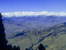
We reach Peo (2290 m/7,512 ft) at 4.30 pm, good 20 hours after starting from Delhi. Stretching to let the vertebrae click back into their respective slots we marvel at the peaks looming almost overhead. Kinner Kailash, Jorkanden peaks, both over 6000 m high rise into the sky, just across the Satluj. Travel books and sites have correctly described these as 'shark-fin' shaped. Chilgoza trees abound (these grow in the wild - all efforts at commercial plantation style have apparently failed). We then get busy organising a room to stay; porters for the morrow, as well as a drop to the village Thangi (2660 m/8,725 ft) 41-km away, from where the trek is to start.
On day three, we get cracking by 7.30 am, reaching Thangi after 10.00 am (had to stop to repair puncture, en route). The road to Thangi isn't for the faint hearted or for those with vertigo. The driver drives as though he's on a four-lane road. Only that it is a sliver of tarmac, and the more excitable of the group constantly urge the driver to be careful - something that he studiously ignores.
We start the trek by 11.00 am. All groups need to get registered at the ITBP post at Thangi which takes a while, as the post is way above Thangi. The village is in an incredibly green, but narrow gorge. The sides rise steeply - very picturesque. One needs to spend a day of two here, just to take the surroundings in. We don't have this luxury.
Day four sees us walking along the Nala to Charang village, some 5 km away. This is the gentlest of stretches one covers on this trek. Snow-covered peaks loom around the village around which there is plenty of flat agricultural land. At 10.30 am the village is all but deserted, only the elderly sit in the yards, their prayer beads in hand, taking in the summer sun. A collage of stone scriptures greets one at the entrance of the village, in a variety of scripts: Pali, Prakrit, Tibetean. A veritable treasure trove for those interested in ancient scripts.
On day five, we laze, waiting for the sunlight to find our tent. We start after 10.00 am, walking along the nallah, reaching Lalanti (4200 m/13,776 ft) at 1.30 pm. One has to be careful en route, though. If you follow the footpath (as it leaves the stream) you will be stuck on the higher reaches of the surrounding peaks. Two of us made that mistake, and had to slide down to safety, minus the seat of our pants.
A large group of people pitch tent, 20-minutes upstream. They had not crossed us, so they must have come from the other side, from our destination Chitkul. We hurry across, and are not surprised to see it is a single foreigner with 8-10 porters. He turns out to be Garry Weare, the Lonely Planet correspondent, doing an update. "There is plenty of snow on the pass," he says. "We had to cut our way down. Just retrace our steps, and you will be fine." Providence is indeed, on our side. "Head for Chitkul, should take you nine hours," we are told. Four hours to the base of the pass, one for the climb, and four hours for the walk down to Chitkul.
We start day six early eating only a few mouthfuls of khitchdi prepared the previous evening. Clearly, we are all nervous. Two in our group suffer from altitude sickness. Ideally, we should have headed to lower altitudes, but elected to press on. Just one day's trek remained. We set course at 7.20 am, hoping to be at the base of the pass at 11.30, on the pass by 12.30, and in Chitkul by 5.30 pm at the outer. Easier said than done!
We reach the base of the pass at around 4.00, almost nine hours into the trek! "How on earth are we going to get up that one?" we ask each other. There is no route or path up the pass, which is at a 55-60 degree angle. Too stoned with fatigue to discuss the best way forward, we attack the climb. Failure to climb would condemn us to spend the night on the snow and walk two days back to Shruting, without food. There was more than pride at stake here. We are on all fours, kicking footholds into the ice, and move across to catch the tracks of the team that had descended the previous day.
We rest for 20-30 minutes, failing to note the remote beauty of the valleys both before, and behind us. "Got to cross the snow line by night fall," we mutter and set off down towards Chitkul. We pick up speed as we negotiate the scree and loose rocks, slipping and stumbling down like drunks. The five us are strung out over a few hundred metres and as one neared the end of the snow line, a hysterical scream overtook us. We froze in our tracks knowing that someone was in trouble. And from the way he was ranting, it appeared bad.
It was close to twilight: we were dog-tired and just did not know how to get the strength to turn around and climb halfway up the pass to our stricken comrade. "Let us send a porter to Chitkul and ask for air-evacuation," was a suggestion. One of the porters retraced his steps and led the unfortunate trekker to where we had gathered. Luckily, it was just passing hysteria and there was no physical damage, as we had feared.
Pressing on using torches, we find the most suitable spot available on a snow field and pitch tent. That night, after 12 grueling hours on the move, we try and sleep on empty stomachs, being out of food. We wake up every hour, sleeping only between 2 and 4 am. It snows at night: we can hear the flakes falling on the outer cover of the tent. Yet we are warm and fairly comfortable.
Crossing the snowline, we enter a steep gorge, littered with smashed rocks and boulders. A local had been killed here, when a loose rock struck him, last season or the one before. The unasked questions were answered in a moment we heard the unmistakable sounds of rocks cracking off the mountainside, and with a series of sickening noises, four headed towards us, and all had to take evasive action. We could smell the flint as they whizzed past like giant crazy balls. We knew that as long as we were in this gorge, we were vulnerable. Push them tired feet, dammit! Walking up may be strenuous, but down a mountainside is infinitely more painful on the feet.
Jumping from boulder to boulder, we urge each other on, calling out for the laggards to keep pace with us. Hour follows the hour and the gully seems never to end. Finally just after noon, the gully evens out into a broader valley and we are walking on mud! Black, gorgeous and soft mud: not too many rocks here. Moments later, we stumble across a shepherd who tells us that Chitkul (11,316 ft), is 10 minutes away. We trudge along for 50 minutes before we enter the peaceful and pretty village, and find our way to a guesthouse. Getting out of our wet boots and clothes, we crawl under warm blankets after wolfing down a steaming bowl of noodles and egg. That night, we all sleep peacefully in a warm and dry room.
We have trekked around 55 kms in five days, clocking close to 35 hours on the move, starting from 2660 m (8725 feet), peaking at 5280 m (17,320 ft), and were now at to 3450 m (11,316 ft).
Day eight began very early when we boarded the 6.30 am bus to Karcham, on the Shimla-Peo highway. We cross Sangla and Rakcham, which are also in the verdant Baspa valley, often referred to as the most scenic vale in all Himachal. It is another wet day and we thank the stars for pushing ourselves during the trek. Things could have gotten cuter had we been out on a day like this. By 9.15 am, we were on a Shimla bound bus, which we reached at 6.20 pm. Ten minutes later, we were on a Delhi-bound bus - we decided to do all the resting once at home. We reached ISBT, Delhi by 3.30 am on day nine, and home, 30 minutes later.
|
|||||
Editor: Romola Butalia (c) India Travelogue. All rights reserved. |
|||||
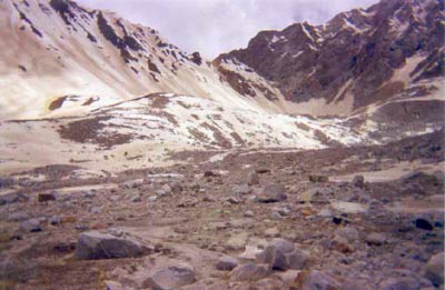
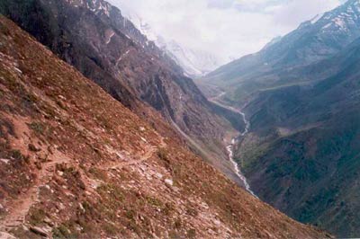 The route to Lambar (2930 m/9,611 ft), 11-km from Thangi, has its moments, where a missed step would mean curtains. We have to cross the Gorang Nala twice, on log bridges, a few feet above roaring waters. After a lunch halt at Lambar, we proceed to Shruting (3370 m/11,054), which is essentially a ITBP transit camp, 10 kms away. We all stagger into Shruting by 6.40 pm. Shruting is at the confluence of two mountain rivers, and the valley broadens a couple of kilometres before one reaches here. We are grateful for the hot cuppa the jawans ready in a jiffy. Once necessary permissions are taken, the ITBP jawans play gentlemen hosts. They offer us the local Barley-beer, saying that one could quaff down as much as one wanted, as this did not result in a hangover. With three hectic days behind us and god-knows-what yet to come, we overdid the drinking, foolishly believing that our bodies needed that extra bit to unwind. We awoke the next morning with the biggest hangover we could remember experiencing. The jawans certainly enjoyed that one at our expense!
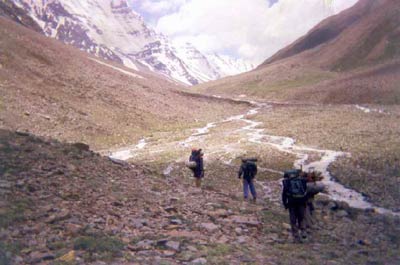 Deciding that we would avoid trekking to Rangrek monastery a few kilometres beyond Charang, we proceed up a steep mountain side going up and up for three unrelenting hours, to Lalanti La. The measly footpath then hugs the mountainside, as we round the tip of the mountain and enter a broad valley. The snow line seems to be in touching distance. We have been climbing these five hours and must be around 14,000 feet. We lose altitude as the track descends dangerously into the valley floor. Pitch tent in the meadow, among strewn rocks, eat lunch-cum-dinner at 6.00 pm. Another long day. We decide to take it easy on the morrow. All five of us (we had two porters) cram into the four-man tent for the night.
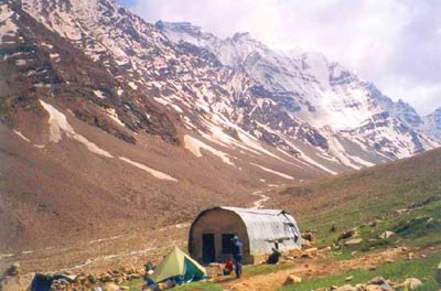 Lalanti has a basic pilgrim shelter, which is too dank and dirty to use. We pitch tent and doze in the sun for a couple of hours. We can sense, we are very near the La (pass) as the valley has broadened, and the jagged, snow-laden peaks watch over us, silent and brooding. There is hardly a sound here, but for the angry sound of the nallah a few hundred feet away. Though we cannot see Kinner Kailash, believed to be the summer abode of Lord Shiva, we can almost sense its towering presence. It is almost one km higher than where we are.
 By 10.00 am, we were struggling. The pass was still quite a distance away, at least two hours, said our porters. We are already hungry, and try to eat lunch of atta halwa. Cannot eat more than a few mouthfuls of this either. We all doze in the sun for a while and get moving. Progress is slow: we complete a breathing cycle for each step taken. Moraine follows moraine, and we climb up one, drop into the next, moving from rock to rock. There is no soil here, and we could have been on the moon. We are above the snow line now and warily trudge across snow, and leap from ice block to the next to cross the ice-cold streams, born in front of our very eyes. The walk is unending, and we stop checking the time, lest that pulls us down even further.
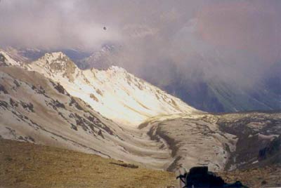 The going gets even slower: 20 steps and a break, 20 steps and a break, 15 steps and a break. After all, it is around 17,000 feet here. We inch our way up, just catching each others eye for reassurance, and then moving on. We get to the pass at 17,329 feet (almost as high as the Everest base camp, which is just 200 feet higher) around 5.00 pm, and our eyes almost pop out of the sockets! The way down looks even more treacherous Why were we not channel surfing at home at this very moment? What madness drove us to try this trek?
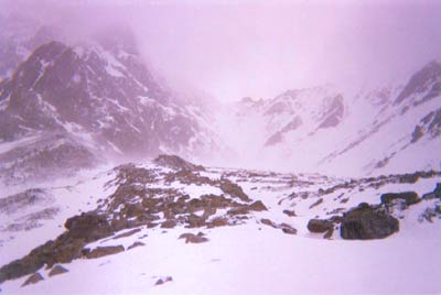 Day seven is a cloudy and wet day. All our equipment is under snow. All clothing inside the rucksacks is cold and wet. Attempts to melt snow have to be made in the tent, on the gas stove. Just as a pail of water is ready, someone accidentally knocks the damn thing off. Luckily the tent is spared. Ice and glucose for breakfast, gentlemen? We are off at 8.00 am. We walk in single file, taking solace from the fact that the worst is behind us and that a hot meal is 4 to 5 hours away. It is a cloudy day and our vision is limited to 30 to 40 metres.